Before there was a Bonney Lake – or even a Washington state, for that matter – waves of settlers made their way across the country to start new lives in the Oregon and Washington territories.
It was a long and treacherous trek, especially for those who veered north toward Seattle.
In 1853, the first wagon train to successfully cross the Cascade Mountains, led in part by John Longmire of Indiana, rolled through the Naches Trail and down the western side of the mountains. The journey took settlers into present day Pierce County, passing through where the city of Bonney Lake presently sits.
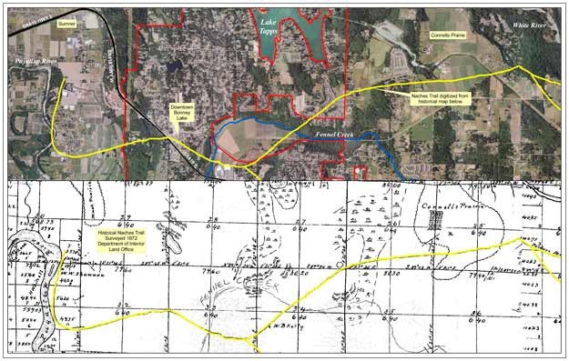
This summer, a team of citizens, along with employees of the Bonney Lake Geographic Information System Department will be walking the trail, attempting to map exactly where the first settlers passed through the city.
“What we’re looking at mapping is the original Longmire wagon train trail,” said Winona Jacobsen, a Planning Commissioner and member of the Greater Bonney Lake Historical Society.
Jacobsen, who has been instrumental in the push to map the historic route, said she has been working with Oregon-California Trails Association as they map the Oregon Trail, of which the Naches is an offshoot. Jacobsen said the trail into Pierce County has been mapped to Porter’s Prairie near the White River and this summer they plan to do the next leg, through Bonney Lake to the Puyallup River.
Jacobsen said it is important to know the route as a way to get in touch with the area’s history.
According to Alan Catanzaro, Bonney Lake GIS Analyst, there has been interest in mapping the Naches Trail through the city for at least five years and though an estimated route is included in the parks element of the city’s comprehensive plan, plans are to try and find an exact route this summer.
“The current effort is to really pinpoint the trail and try to map the thing as well as possible,” Catanzaro said.
To start, Catanzaro took an 1872 map from the U.S Department of Interior General Land Office Map and used the public lands grid to match the original map with a modern, digital equivalent. Once that was completed, the Naches Trail, which appears on the 1872 map, was superimposed on the current map, giving the city a general route.
“The GIS is just perfect for stuff like this,” Catanzaro said.
The combined map shows the Naches Trail crossing the White River near Buckley and then passing through Connell’s Prairie – another historical site for the city – before turning through Finnell’s Prairie, the original name of the property on which the Kelley Farm sits, before heading down Ehli Rim Road right past where the Dairy Queen now sits.
“Sure enough, the trail goes right through the state Route 410-Sumner-Buckley Highway interchange,” he said.
Catanzaro said there are no remnants or markers on the trail, something the city is hoping to take care of this summer by sending people to walk the trail while wearing special backpacks containing GIS equipment to mark the path.
Catanzaro said Jacobsen has been working to find more exact locations by searching through historical maps and texts and trying to match locations, but both said no one is really sure, for example, exactly where the wagon trains crossed the White River.
They are hoping the public might be able to provide additional information to help them on their project.
“Residents out there might have information for us,” Catanzaro said.
Catanzaro said the Naches Trail will be treated like a park element in the 2011 Comprehensive Plan update.
“It’s a cultural resource,” he said. “Whenever you understand the history of your neighborhood it enriches the experience.
“There’s a rich history in Bonney Lake,” he continued. “It should be understood.”


